


Territorial Boundaries and Location
The Bangwa tribal area comprises eleven village communities, clearly defined by natural and ethnic boundaries. To the north, the region is bordered by the Bamumbu Village area. The eastern boundary follows a prominent watershed that historically served as the international boundary with French-administered territory, lying approximately between 5°20’ N and 5°40’ N.
To the south, the boundary is marked by the River Fi, also known locally as Misur or Betsu. This river runs along the southern limits of the Foreke-Tcha-Tcha and Fotabong II village areas and forms a natural division between the Bangwa and their Nkongwa neighbors. On the western side, the Bangwa territory is bordered by the Mbo, Elumba, and Bayangi tribes.
Watershed and River Systems
One of the most striking physical features of the Bangwa region is the watershed that defines the eastern boundary. From this elevated ridge arise several major rivers, including the Manu, Ma, Bago, Mfu, and Betsu, along with countless tributaries. All these rivers flow westward and ultimately contribute to the Cross River system, making the watershed a critical hydrological feature of the area.
Climate and Rainfall
The region experiences exceptionally heavy rainfall, largely due to its high elevation. The lowest strata of rain clouds average around 5,000 feet, while the watershed itself ranges between 5,000 and 6,000 feet above sea level. This elevation contributes to prolonged and intense rainfall.
During the period from July 20 to October 20, rainfall is estimated to reach 30 to 40 inches per month, although precise measurements were not obtainable. Temperature varies significantly with altitude, and in higher areas such as Fosimongdi, evenings during the rainy season can become extremely cold.
Topography and Settlement Patterns
The Bangwa people inhabit a rugged mountainous landscape, with elevations ranging from approximately 2,900 feet in the Fontem village area to as high as 6,500 feet in Fosimongdi. The average altitude across the region lies between 3,000 and 4,000 feet.
Settlements are typically arranged in compounds scattered along mountain slopes. Chiefs generally reside on the peaks, symbolizing authority and visibility, while hamlet heads are often located in valleys or hollows between summits.
Terrain and Accessibility
The terrain is characterized by exceptionally steep gradients, with slopes of 1 in 2 being common. For example:
The distance between Fosimongdi (5,700 feet) and Tschati (2,500 feet) is roughly three miles, representing an average descent of over 1,000 feet per mile.
Hamlet settlements near Tschati, located about two miles away, lie between 3,300 and 4,400 feet.
In the Foreke-Tcha-Tcha area, the journey from Sonfi to Foreke, though only two to three miles, requires a severe two-and-a-half-hour scramble over broken rock formations.
The River Bago drops from 2,950 feet at Fontem to 700 feet at Mombobisuk over a distance of approximately eight miles.
These variations are representative of the entire region.
Travel across the territory is extremely demanding. While the distance from Fotabong III in the south to Folepi near the northern boundary is only 23–25 miles as the crow flies, a journey that could be completed in one day on a good road would require five to six days under existing conditions.
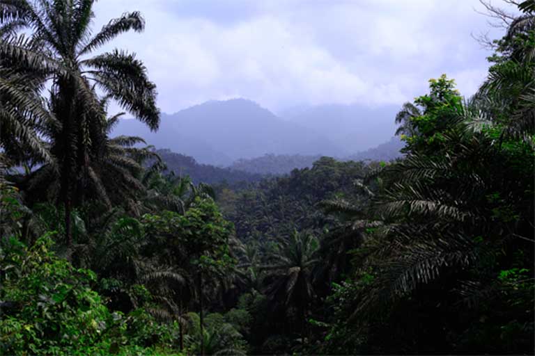
Vegetation and Soil Composition
At elevations above 3,000 feet, dense forest gives way to open bushland, gradually transitioning toward pasture-like terrain. The soil across much of the region consists of tenacious red clay, which is generally poor for agriculture and construction. However, at lower elevations, soil quality improves considerably, becoming rich in leaf mould and more suitable for cultivation.
Strategic and Economic Observations
The country is largely open, with limited thick bush. While this openness might suggest accessibility, the steep terrain severely restricts movement. Any large-scale military operations would require significant resources and coordination to be feasible.
No evidence of economically valuable minerals was discovered during observations, nor was any reliable information obtained regarding their presence.
Conclusion
The Bangwa tribal area is defined by its dramatic topography, heavy rainfall, and complex river systems. Its mountainous terrain shapes settlement patterns, limits accessibility, and influences both climate and land use. While rich in natural features and cultural organization, the region presents substantial challenges for transportation, agriculture, and large-scale development.

💬 Comments